Compass error refers to a magnetic compasses natural tendencies to produce erroneous readings in certain circumstances. Sometimes this may be due to environmental effects such as proximity to a strong magnetic field. Compass error is also frequently the result of shortcomings or anomalies in the way compasses work.
Compass error due to environmental effects usually refers to a vessels compass being drawn toward the magnetic fields generated by the engines. This is called magnetic deviation. Additionally in some regions with high concentrations of iron in the soil, compasses may give all sorts of erroneous information
1. Definitions
True North: This refers to the geographical North Pole. This is a physical pole since the axis of the earth passes through the same. All charts are aligned to this pole and the co-ordinate system refers to this as the North Pole.
Magnetic North: This is the south-seeking pole of the earth when considered as a giant magnet. All magnetic compasses point to this pole as North. The physical and the magnetic north pole do not coincide. The magnetic pole shifts over time as the earth cools down and also due to other various reasons. The physical pole remains stationary.
Compass North: This takes into account both variation and deviation experienced by the compass while pointing the direction of North. It is not possible to have two ships compass point at the same direction as North.
Magnetic Course: The angle between the magnetic meridian and the direction of the ship’s head. It defines the direction of the ship’s head relative to “Magnetic North”. The difference between the two is the Variation.
True Course: After allowing for Deviation and Variation to the Magnetic Course/bearing.
Compass Course: The angle between the compass needle and the direction of the ship’s head. It defines the direction of the ship’s head relative to “Compass North”. The compass course is indicated by the position of the ‘lubber’s line’ relative to the compass card. Both deviation and variation are involved in this correction.
DEVIATION: The compass needle is affected when VESSEL electrical equipment is operated and by the ferrous metallic components within the vessel. These internal magnetic fields tend to deflect the compass from alignment with magnetic north. This tendency is called deviation. Deviation varies, depending upon which electrical components are in use.
The local magnetic field may also change as a result of mechanical jolts to the vessel, from the installation of additional or different radio, equipment, or major mechanical work on an engine such as changing of the crankshaft or propeller. The crankshaft and the propeller are particularly susceptible to changes in inherent magnetism because they rotate in various magnetic fields.

<METHOD AND KIND OF COMPASS ERROR MEASURING>
As we know there have two kind of compass gyrocompass & magnetic compass each of them has compass error GYROcompass error ▲G & magnetic compass error ▲C How to correction compass error is necessary and important
2. Measure compass error by wharf
This kind of method is simple to get gyrocompass error. When we berthed at wharf after all line make fast ship`s for&aft centre line(keel line) direction will be same as wharf direction according to this we can measure our gyrocompass error.
FOR EXAMPLE berthed at PKG Malaysia wharf NO.11 whis portside alongside check GYRO course(HDG)is 181.5
Measure the no.11 wharf direction is 181.7 (see picture).


So ture couse TC=181.7, GYRO courseCC=181.5
According to TC=CC+▲C, SO: ▲C=TC-CC=181.7-181.5=0.2E, Our gyrocompass error is 0.2E.
3. Measure compass error by object bearing

At first on the chart select two object which is apparent see:
This two object distance should be suitable and top of apex aline cross our ship`s rout
1) Ship arr A position check the bearing of the far object and keep which .
2) when the two object alined (ship position at B) at the moment record this two object bearing this is CB(compass bearing because we use GRYO-compass get object bearing so CB is gyrocompass bearing)
3) At chart we can get ture bearing of this two object TB

4).TB=CB+▲C, SO: ▲C=TB-CB
4. Measure compass error by sun
EXAMPLE >
2018.05.22 06h24m13s LT(ZD+08), ship position LAT 16°44.4`N LONG 113°09.5`E.
SO, UTC 2018.05.21 22h24m13s.
Calculate &measure gyrocompass error
1) first according to UTC22h24m13s reference book tablet (NAUTICAL ALMANAC)
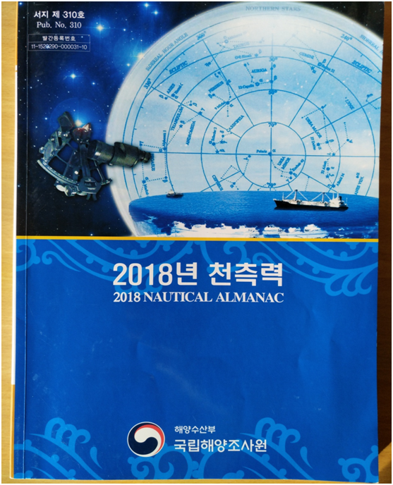
2) Use data 21ST MAY 2018 UTC22h lookup GHA & Dec.at see booklet

Get GHA=150°50.7` Dec=20°18.8`N
Than correction of 24m13s GHA

Correction GHA=06°03.3`
So 2018.05.21 at UTC 22h24m13s
GHA=150°50.7`+06°03.3`=156°54.0` Dec=20°18.8`N
3) According to LHA=GHA+LONG(-W,+E)
GHA 156°54.0`
+ 113°09.5`E
LHA 270°03.5` E
4) Now we get LHA and use LHA, LAT, Dec, and data 21ST MAY 2018 lookup sun TB at booklet(sight reduction tables for marine navigation)

5) First at the main date use LHA=270 LAT=16 Dec=20 Lookup the sun bearing=70.7°

6) use same step of method to correction
LHA corr = 3.5(70.7-71.0)/(270-271)60’ = 0.02°
LAT corr = 44.4(70.7-70.8)/(16-17)60’ = 0.07°
DEC corr = 18.8(70.7-69.7)/(20-21)60’ = -0.31°

SO : 70.7°
+0.02°
+0.07°
-0.31°
Z 70.48°
7) BECAUSE LHA LESS THAN 180°
{Zn=360-Z=360°-70.48°=289.5°}
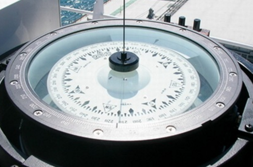
8. Use AZIMUTH CIRCLE At UTC 22h24m13s PSN: LAT 16°44.4`N LONG 113°09.5`E
get sun bearing GB=290.0°

9. So ▲C=Zn(TB)-GB
=289.5-290.0
= 0.5W
At last we should be knew
TC=GC+▲G=MC+▲C
TB=GB+▲G=MB+▲C
▲C=(var+dec)


댓글